• ABOUT – DICK YOUNG
  • YWMF – ARCHIVES

Young's World Money Forecast

Since 1978 With a 32 Year Vacation

  • DICK YOUNG
    • FROM RICHARD C. YOUNG
    • THE FINAL INTELLIGENCE REPORT
  • INVESTING STRATEGIES
    • RETIREMENT COMPOUNDERS®
    • GOLD & SILVER
  • DIVIDENDS & COMPOUNDING
    • MIRACLE OF COMPOUNDING
    • DIVIDENDS
  • GRAHAM & RUSSELL
    • BEN GRAHAM
    • RICHARD RUSSELL
  • THE DOW AND THE LEADERS
    • DOW vs. S&P 500
    • DOW vs. DOW DIVIDEND PER SHARE
  • WELLINGTON MANAGEMENT COMPANY
  • YOUR SURVIVAL GUY
  • BANK CREDIT & MONEY
  • THE PRUDENT MAN

CAT 5: Prepare for Hurricane Lee

September 8, 2023 By Richard Young

Hurricane Lee has strengthened to a Category 5 storm and is barreling through the Atlantic on course to hit America’s East Coast. Right behind Lee is Tropical Storm Margot, which is also expected to reach hurricane levels. First Coast News reports:

It’s very active across the Atlantic basin, but thankfully there are no local threats in Jacksonville within the next week. Remember to stay updated this time of year as the historical peak of the Atlantic hurricane season is approaching.

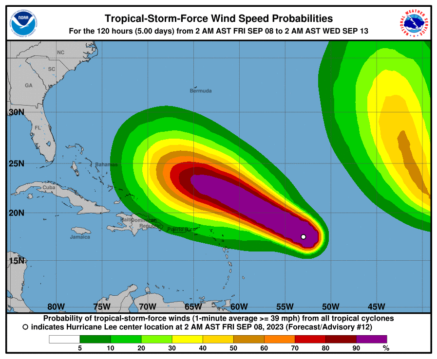
Tropical Depression 13 has formed in the Atlantic, and it is forecast to become a major hurricane by Saturday. We are watching it closely as models suggest it could head towards the Caribbean, or travel just north of the islands and near the Bahamas by mid-next week. It is too early to tell how this could impact the East Coast of the United States, but it is something to watch closely. Guidance continues to be strong on the development of this area as it moves west this week.

Hurricane Florence was said to be a “guaranteed fish storm” in its early beginnings in 2018, but the forecast changed and it ended up making a direct impact on the Carolina Coast. Not that this current system we’re watching won’t re-curve, but Florence does serve as a reminder to not write these tropical waves off too soon. Stay tuned for updates.

There are two other areas we’re monitoring as well, but do not pose a concern to us at this point. Post-Tropical Cyclone Franklin is located several hundred miles north of the Azores and is forecast to move quickly southeastward towards warmer waters east of the Azores. Another strong tropical wave is forecast to move off the coast of West Africa on Tuesday and head toward the Cape Verde Islands.

It’s already been a very active season. Normally by now, we’d only have 7 named storms. Instead, we’ve already had 11 (12 if you include the one unnamed subtropical storm in January), which is more typical for October 2.

Read more here.

Related

Filed Under: Investing Strategies

Compensation was paid to utilize rankings. Click here to read full disclosure.

RSS New From Young Research & Publishing

  • Work to Retirement #11: Whatcha Gonna Do?
  • Canada Rescinds Tech Tax, Resumes Trade Talks with U.S.
  • US Investment Gap Narrows in Q1
  • Why the ‘Big Beautiful Bill’ Could Fix America’s Broken Grid
  • Smartphone Satellite Communications Are Here
  • Income Falls as Government Cuts Welfare Spending
  • US and China Finalize Rare Earth Trade Deal
  • GPS Jamming Disrupts Strait of Hormuz Despite Ceasefire
  • Could Blue Blob New York City Get a Lot Worse?
  • Economic Fundamentals Show Stability Beneath GDP Decline

RSS New From Your Survival Guy

  • Work to Retirement #11: Whatcha Gonna Do?
  • How Does Internet from Space Work?
  • The Lay of the Land: Who Can You Trust?
  • The Economy: Mixed Signals and the Fog of War
  • MARVEL: An Energy Superhero
  • How Was the Trip?
  • SAFETY FIRST: What’s Your Margin of Safety?
  • Complex, Costly, Often Illiquid, and Uncertain
  • Oil Shock? Not So Much
  • Le Petit Lutetia

Search Our Site

Richard C. Young & Co., Ltd.

–Client Letter Sign Up–

Sign up to receive email alerts when our latest client letter is posted on our website.

Copyright © 2025 · About Dick Young · Terms & Conditions


Loading Comments...